A Location-Based Service for Independent Mobility
Wayfinding can be defined as knowing where you are, knowing where your desired location is, and knowing how to get there from your present location. For outdoor environments, recent advances in global positioning systems (GPS) and mapping technologies provide accurate and simple to use means for wayfinding. Reading and following signs remains the predominant mechanism for receiving wayfinding information in areas without GPS coverage. This puts people who are blind or visually impaired (BVI) at a great disadvantage. Similarly, for people with mobility impairments requiring the use of wheelchairs or walkers, the determination of accessible pathways to a destination remains inefficient by following visual cues. For older adults with cognitive impairments, it may be difficult to comprehend signage and find their way around in unfamiliar areas. Thus, there still remains a great need to provide a low-cost, easy to use, and reliable wayfinding system within indoor and outdoor spaces that complements existing satellite-based systems. A solution to this “auxiliary” wayfinding problem for people with disabilities in our communities also has broad applications for the rest of the general population in unfamiliar, disorienting spaces.
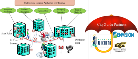
CityGuide is envisioned as an smartphone app (interacting with strategically placed BLE beacons or using computer vision techniques to get location details) used by the population of a community to access various location-based services (LBS) beyond what is possible with just a GPS-based system. CityGuide can complement a GPS navigation app by providing applications such as the following: wayfinding, emergency evacuations, landmark description, transit boarding.